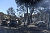

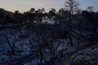
ATHENS, Greece (AP) — A European Union satellite mapping agency says 104 square kilometers (40 square miles) of land was burned northeast of Athens this week during a deadly wildfire that gutted scores of homes and prompted multiple countries to send assistance.
The Copernicus Emergency Management Service announced the damage estimate Wednesday, a day after the wildfire was contained in a massive effort that ended on the outskirts of the capital.
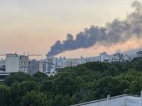
A factory worker was killed in the fire that swept through mountainous areas southward, covering an area almost twice the size of Manhattan and blanketing the Greek capital with a thick cloud of smoke.
The fire damaged 22 businesses and rendered at least 78 homes uninhabitable, with nearly half of them completely destroyed, Greek officials said Wednesday. Inspections in fire-afflicted areas will continue in coming days.
Nine countries, including neighbor Turkey, sent assistance to Greece to boost ground crews and water-dropping planes and helicopters operating outside Athens.
The wildfire follows successive heat waves across southern Europe and low levels of rainfall this year.
According to an updated estimate by the ��ɫֱ�� Observatory of Athens, over the past eight years 450 square kilometers (174 square miles) of forest have been burned in the Attica region that includes Athens. That amounts to 37% of the region’s total forested area.