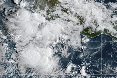
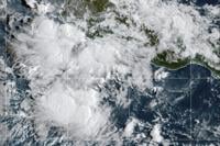
This GOES-19 GeoColor satellite image taken Friday, Sept. 12, 2025, at 10:10 a.m. EDT and provided by NOAA, shows Tropical Storm Mario in the Pacific Ocean off the coast of Mexico. (NOAA via AP)
This GOES-19 GeoColor satellite image taken Friday, Sept. 12, 2025, at 10:10 a.m. EDT and provided by NOAA, shows Tropical Storm Mario in the Pacific Ocean off the coast of Mexico. (NOAA via AP)
MIAMI (AP) — Tropical Storm Mario formed Friday off the Pacific coast of Mexico and was expected to bring wind, rain and possible flash flooding, forecasters said.
Mario was described as “mini” in the ��ɫֱ�� Hurricane Center's morning advisory, but the storm packed maximum sustained winds of 40 mph (64 kph).
A tropical storm watch was in effect for parts of the Michoacan state. It spanned from Lázaro Cárdenas to Punta San Telmo.
The Miami-based weather service said Mario was centered about 40 miles (64 kilometers) south-southwest of Zihuatanejo, Mexico, and about 60 miles (97 kilometers) south-southeast of Lázaro Cárdenas.
Forecasters said the tropical storm was expected to strengthen in the coming days.
Rainfall estimates were around 2 to 4 inches (5 to 10 centimeters), with isolated locations seeing 6 inches (15 centimeters). Higher terrain could experience flash flooding. Windy conditions were possible Friday for coastal areas in Guerrero, Michoacan and Colima states.